")
Groundwater is Africa’s hidden lifeline, but managing it equitably requires real-world data and hydro-diplomacy. This feature story follows the work of the G4DR project in piloting a transboundary groundwater monitoring network in two aquifer systems – which could provide a blueprint for rural water security across the continent.
When the dry season grips the Mono River Basin and the surface water retreats, the true lifeline of the borderlands between Togo and Benin comes into play. It isn’t found in the riverbed, but deep below the earth.
For the many millions of rural residents across Africa, groundwater is the ultimate safety net against climate change. When the rains fail and the rivers run dry, it is the invisible aquifers below ground that keep crops alive, children in school, and communities intact.
Yet, for decades, this transboundary resource has remained largely unmeasured, and in some areas is increasingly under threat. You cannot protect what you cannot see, and you cannot sustainably manage an aquifer that crosses international borders without knowing what is happening beneath the soil of your neighbours. A transboundary aquifer can be freely pumped by one country, inadvertently lowering the water table and drying up rural community wells in another.
But unlocking this hidden and often misunderstood resource requires more than just goodwill; it requires real-world data (and more than a little on-the-ground detective work to get that data).
Under the Global Environment Facility (GEF)-funded Groundwater for aDvancing Resilience in Africa (G4DR) project, teams of hydrogeologists and local officials recently set out across the Mono River Basin (shared by Togo and Benin) and the Shire Aquifer System (shared by Malawi and Mozambique) on a critical mission: the hydro-census.
The anatomy of a well
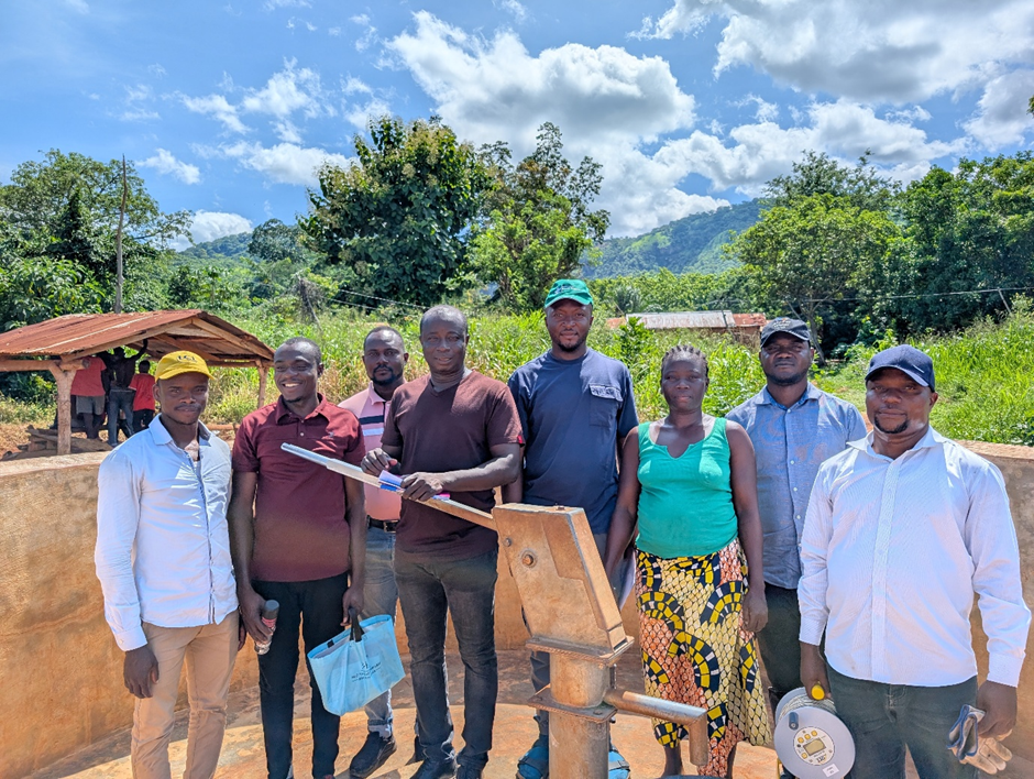
Boreholes are narrow, deep shafts drilled into the earth to reach the water table. Generally speaking, there are two main types. Most people are familiar with production wells. These are community boreholes equipped with handpumps or motorised pipes designed specifically to pull water out for drinking, sanitation, and agriculture.
However, a scientific hydro-census is primarily searching for monitoring boreholes (also known as observation wells). These are not designed to extract water; instead, they are essentially dedicated listening posts.
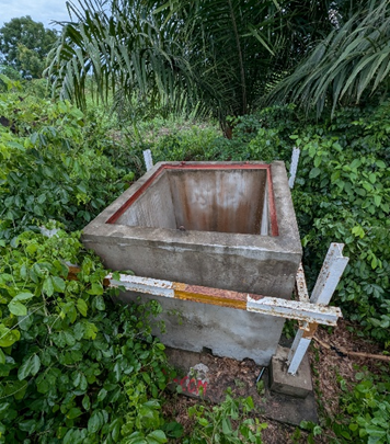
While a community-dug, rural production well might only need to be 20 meters deep to reach drinking water, a monitoring borehole often needs to be drilled much deeper to accurately assess the long-term health of the entire aquifer system,
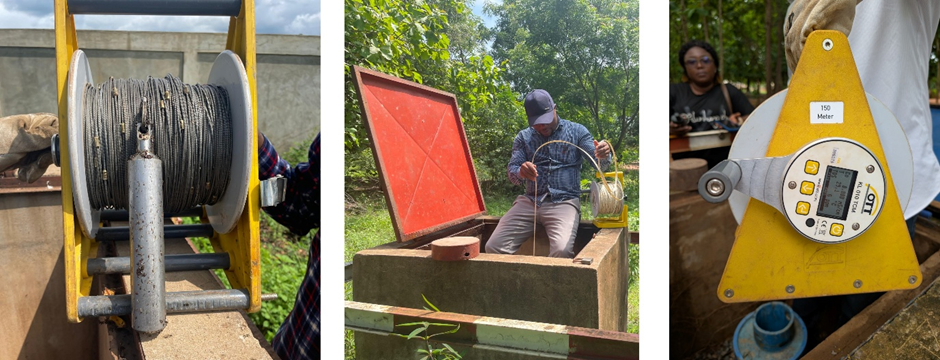
From these monitoring boreholes, you can measure groundwater level, and in many cases temperature and electrical conductivity, which is an indicator of water salinity and by extension coastal saltwater intrusion.
explains Dr Girma Ebrahim, a lead hydrogeologist working on the project.
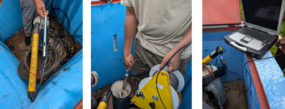
These measurements can be done manually with a dip meter, which involves dropping a probe down the borehole and unwinding a graduated tape until the probe contacts water, triggering an audio or visual alert.
Alternatively, a submersible data logger can be permanently installed (suspended on a cable) to provide continuous measurements over time, which can then be downloaded for analysis (or ‘beamed’ to the cloud in the case of more advanced setups).
The reality on the ground
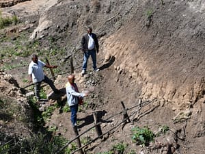
Prior to the G4DR teams deploying to the field, national databases suggested a healthy distribution of functional monitoring boreholes in both basins. The reality on the ground, however, revealed that approximately a third were not actually functioning, due to varying degrees of damage – leaving a sizeable dent in any hoped-for monitoring network.
Fortunately, in the Mono Basin the team determined that, given the right rehabilitation work, these non-functioning boreholes could be resorted and successfully monitored. Most sites in the Shire Aquifer, however, were completely blocked or extensively damaged rendering them beyond saving.
We couldn’t find suitable observation boreholes to rehabilitate,
Furthermore, existing community handpump wells were too shallow, at only around 20 meters, to effectively monitor the deeper aquifer system and being remote and far away from government oversight presented a significant security challenge.
Dr Ebrahim said.
A technological trade-off
In a vital first step for regional water diplomacy, technical teams sat down to co-design entirely new transboundary monitoring networks.
Every GPS coordinate for a new borehole had to be discussed, scientifically validated, and jointly agreed upon to ensure both sides of the border would benefit from the data
Dr Ebrahim reflects.
This process required navigating intense logistical and technical hurdles, particularly regarding the equipment used to measure the water.
On paper, a high-tech, ‘all-in-one’ telemetry set-up is the dream scenario. It involves equipping a borehole with a data logger, which is in turn connected to a cellular modem powered by a solar panel. In theory that allows you to continuously beam real-time water levels and other data to a cloud server accessible anywhere in the world.
However, the realities of cross-border operations quickly emerged.
When you look at transboundary case studies, you quickly realize there is no single ‘best practice’ you can just parachute in,
It requires intense adaptation and adjustment on the ground.
notes Dr Jonathan Lautze, G4DR Chief Technical Advisor.
The proposed telemetry systems face potential logistical issues: patchy network coverage, incompatibility with local SIM cards across borders, complex foreign currency payment requirements, and data loading and server management bottlenecks. Furthermore, at some sites, the telemetry equipment covers the entire diameter of the borehole, which can make it difficult to perform manual dip-meter checks as a failsafe.
Ultimately, the project pivoted to using data loggers without telemetry, meaning that technical staff need to physically visit the sites and download the data to a device or laptop for analysis.
Another lesson from the project is that, whenever an observation borehole is drilled in a specific location, it’s a good idea where possible to dig a separate production well for the local community to better foster a sense of investment in, and ownership of, the wider groundwater monitoring and climate resilience endeavour.
Uniting ground and surface
Today, as drilling equipment prepares to break ground on these newly co-designed transboundary sites in the Shire, and rehabilitation begins in the Mono, these basins are stepping out of the dark.
The project is currently engaging with stakeholders to develop formal data-sharing protocols. Because these aquifers are connected, pumping or pollution sources in one country directly impact the groundwater availability in the neighboring country.
The current monitoring network is just the beginning, as Dr Lautze explains.
The ultimate goal over the next decade is to proactively integrate the management of both surface and groundwater – a strategy known as conjunctive management,
he comments.
By turning the invisible into the visible, the G4DR project is proving that the deepest resilience doesn’t come from the water itself, but from the communities and countries willing to adapt and manage it together.